A Yellow Level 2 warning for wind and waves resulting in difficulty in navigation at sea is expected along with multiple warnings issued by the South African Weather Service. (Paul Souders/Getty Images)
Multiple warnings have been issued for damaging winds, leading to risk of fires and unruly waves expected in several regions, according to the South African Weather Service.
Impact-based warnings
A Yellow Level 1 warning for damaging winds leading to the risk of localised runaway fires, localised damage to temporary structures, and localised problems for high-sided vehicles on prone routes is expected over the south-eastern parts of the Northern Cape, the south-western parts of the Free State and the northern interior of the Eastern Cape.
A Yellow Level 2 warning for wind and waves, resulting in difficulty in navigation at sea is expected between Saldanha Bay and Cape Agulhas.
Fire danger warnings
Extremely high fire danger conditions are expected over the Central Karoo of the Western Cape, the central and eastern parts of the Northern Cape, the south-western parts of the Free State, and in parts of the interior of the Eastern Cape.
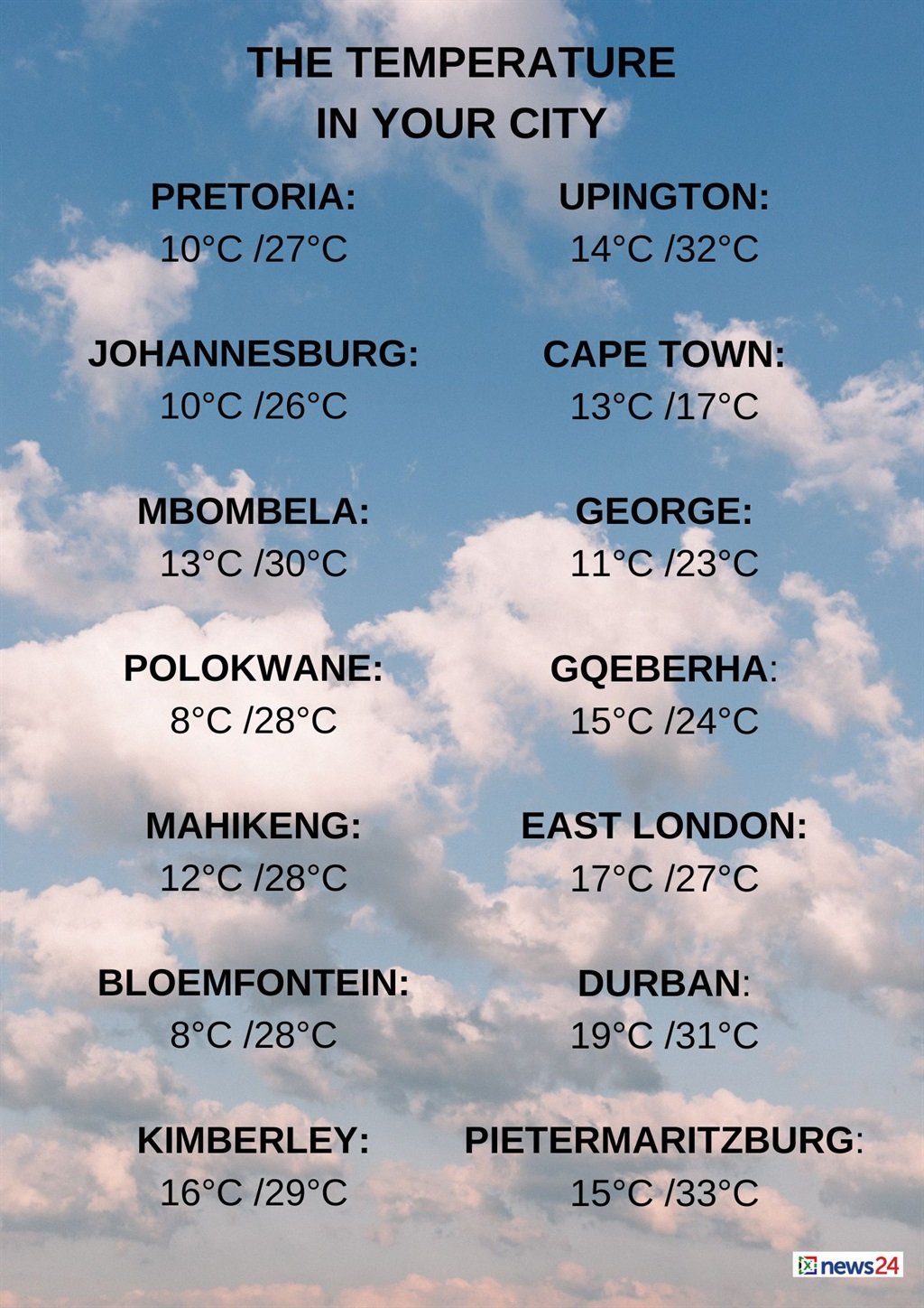
The weather in your region
Gauteng and the North West can expect fine and warm temperatures.
The expected UVB sunburn index is high.
Fine and warm but hot conditions are forecast in Mpumalanga and Limpopo for places in the Lowveld and Limpopo Valley.
The Free State will be partly cloudy over the south-western part, where it will be windy; otherwise it will be fine and warm.
Morning fog patches are expected in the Northern Cape along the coast and over the western interior, where it will be cool.
Otherwise, fine and warm to hot, but partly cloudy conditions are forecast over the south-western high ground and the central and eastern parts.
It will be windy over the central and eastern interior.
The wind along the coast will be a moderate westerly to north-westerly.
The Western Cape will have morning fog patches over the Breede River Valley. Otherwise, partly cloudy skies, and cool to cold temperatures, are expected with isolated showers and rain. Over the eastern interior, however, it will be warm and windy, but with scattered showers over the south-western parts.
The wind along the coast will be a strong to gale force northerly to north-westerly along the south-west coast until the afternoon.
Otherwise, a fresh to strong westerly to north-westerly. It will become a fresh to strong westerly to south-westerly along the south coast from the afternoon.
The expected UVB sunburn index is low.
Cloudy conditions with fog patches are forecast for the western half of the Eastern Cape in the south in the morning.
Otherwise, partly cloudy, windy and warm to hot temperatures are expected. It will become cloudy with isolated showers and rain along the coast west of Cape St Francis in the evening.
The wind along the coast will be a moderate to fresh south-westerly, becoming strong from the evening.
The eastern half of the province will be fine. Otherwise, partly cloudy and warm to hot temperatures are expected.
It will be windy over the interior.
The wind along the coast will be a moderate to fresh north-easterly north of Mazeppa Bay in the morning.
Otherwise, a moderate to fresh south-westerly is forecast, reaching strong from the evening.
KwaZulu-Natal can expect morning fog patches over the north-eastern parts, otherwise fine and warm but hot conditions are forecast in places in the east.
The wind along the coast will be a moderate to fresh northerly to north-easterly, becoming a southerly to south-westerly from the afternoon, but strong south of Durban by the evening.
The expected UVB sunburn index is very high.