The South African Weather Service has warned of disruptive rain leading to widespread flooding in parts of KwaZulu-Natal.
Akaradech Pramoonsin/Getty Images
The South African Weather Service has warned of disruptive rainfall leading to widespread flooding in KwaZulu-Natal.
The rest of the country can expect scattered to isolated showers with fine to warm temperatures and partly cloudy conditions.
Impact-based warnings
An Orange Level 5 warning has been issued for disruptive rainfall which may lead to widespread flooding of roads and settlements, damage to mud-based houses and displacement of communities along the coast and northern parts of KwaZulu-Natal.
A Yellow Level 2 warning for disruptive rainfall leading to localised flooding of susceptible formal/informal settlements, low-lying roads and bridges has been issued for the western and southern interior of KwaZulu-Natal, Mpumalanga, Limpopo (except for the extreme northern parts), Gauteng and the eastern parts of the North West and Free State.
Fire danger warning
Extremely high fire danger conditions are expected over the Dawid Kruiper, KaiGarib and Kareeberg local municipalities in the Northern Cape.
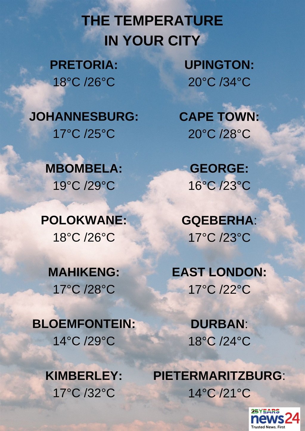
The weather in your region
Gauteng can expect cloudy and warm conditions, with widespread showers and thundershowers.
The expected UVB sunburn index is low.
Cloudy to partly cloudy conditions with cool and warm to hot temperatures are forecasted for Mpumalanga.
Widespread showers and thundershowers are also expected.
Limpopo will be partly cloudy and warm with widespread showers and thundershowers, but scattered showers in the south-west of the province.
Partly cloudy and warm to hot temperatures are expected for the North West, with scattered showers and thundershowers but isolated over the western parts.
The Free State is forecasted to be partly cloudy with warm to hot conditions.
Isolated to scattered showers and thundershowers are expected, except over the south-western parts of the province.
The Northern Cape can expect fine conditions over the interior.
Otherwise, partly cloudy, and warm to hot but very hot temperatures are forecasted for the east.
Isolated showers and thundershowers are expected over the north-eastern parts of the province.
The wind along the coast will be a light to moderate southerly to south-easterly becoming fresh in the afternoon.
It will be cloudy with rainy conditions along the south coast of the Western Cape.
Otherwise, fine to partly cloudy conditions are forecasted with warm to hot but very hot temperatures over the West Coast District.
The wind along the coast will be a moderate to fresh southerly to south-easterly, becoming strong along the south-west coast.
The expected UVB sunburn index is extreme.
The western half of the Eastern Cape will have cloudy conditions with cool temperatures and early morning isolated rain and showers along the coast and in places in the interior.
It will become partly cloudy towards midday.
The wind along the coast will be a light south-easterly.
Cloudy and cool with scattered rain and showers are forecasted for the eastern half of the province, with widespread showers along the Wild Coast and adjacent interior.
The wind along the coast will be a light south-easterly.
KwaZulu-Natal will have morning fog over the interior.
Otherwise, cloudy conditions and warm but cool temperatures in the south are expected.
Widespread showers and thundershowers are forecasted.
The wind along the coast will be a moderate southerly to south-easterly, becoming fresh at times.
The expected UVB sunburn index is moderate.